I went to Mackinac Island which is only accessible by ferry (or a small airstrip)in the Mackinaw straights from Mackinaw city or St Ignace just on the north side of the bridge.
Here's the Mackinaw bridge which connects northern and southern peninsulas.

This is a panoramic of the north coast of Mackinaw City with the bridge on the left

This is taken from the ferry I took, it had quite a big rooster tail.

This is the small airstrip on the island

The straights are busy with freighters

These area couple of the views coming into port
On top you see Fort Mackinac and the village below it

And the Grand Hotel

This is a closer view of the Grand Hotel, I wish I had gotten to explore it further but I was unfortunately short on time.

This is a view of the Mackinac Village from the fort. It's pretty touristy on the coastal road with plenty of shops, restaurants, and many fudge shops. Once off the main street it quiets down quick with many different things to go see. People actually live on the island so many of the houses are original to the island from the Victorian era to modern houses.

Another view of the village from the fort

There are only 3 ways to get around the island. They are by foot, horse or bike. Mackinac Island banned any motor vehicles sometime in the 1890s I believe.
So there are a lot of carriages and horse on the island

As for me I rented a bike and rode at least 15 miles up and down the island for most of the day.

Here's Fort Mackinac. It was originally built by the British during the Revolution because they felt Fort Michilimackinac, which in in Mackinaw City on the mainland, was to vulnerable to attack by the Americans. It was never taken by the US during the war but was given to them and was retaken by the British in the War of 1812 in a surprise attack.
This view is from the village

This is from the opposite side of the fort

This is the barracks for the troops

This is a porthole from one of the watch towers for the soldiers rifles. The ports are narrow inside and wide outside. This way they could cover a wide area while only minimally exposing themselves.

There is another fort on the island as well, it's 325 ft above the water and 168 ft above Fort Mackinac, It's Fort Holmes. I'm not sure why but the British built it after taking Fort Mackinac in 1812, possibly just because of the better viewing area, but it is a basic earthen fort that is very small
This is the blockhouse or entrance into the fort

This is the inside of the fort, pretty small, and I'm on top of the wall

This is the outside of the fort

Here's St Anne's Church. It was established as a Catholic mission in the area in 1670 by Jesuit Father Charles Dablon. The mission itself has been moved several times finally settling where it is now in 1780 and has baptism records back to 1695.

This is the inside of the church

Just one of the beautiful stain glass windows

This is a replica of a bark chapel which is what the early churches/missions looked like

Here are some of the old houses on the island


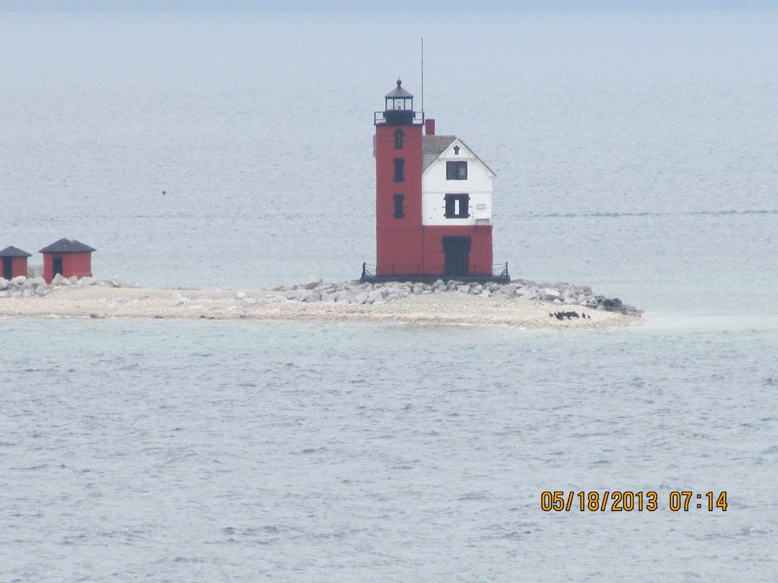
These are the two lighthouses, the old one has been reconstructed, and the new one (white) was built in the 30s by the Coast Guard.

This is the old lighthouse on a neighboring island. This was taken at full zoom with my camera from Fort Mackinac which is pretty far for a clear picture like this.
This is an old style baseball game which they had going on. It's quite different than modern baseball. There are no gloves, and the pitcher threw underhanded. Everyone was dressed for the occasion as well.


On to some of the natural features of the island. The island is mainly made up of limestone so when the lake was much higher than it is today these formations were made due to the erosion of the lake.
This is arch rock looking from the coast. The local Natives believed that this is where the world was created.

Arch Rock from the other side

This is Devil's Kitchen cave. It's large enough for a few men to camp inside and stay dry in wet weather. The black that is on the rocks is from past campfire smoke. People have been coming here for a long time.

Closeup of the right side

Closeup of the soot from campfires

This is Skull Cavern where old remains have been found.

This is Sugarloaf Rock. I wasn't able to get closer to it. There were steps going down to it from the cliff I was on but I had my bike and it would've been a long ride down to it. From the people next to it you can tell how large it is.

The island also has a few freshwater springs
This is Brown's Brook which starts in the limestone and flows maybe 100 yards into the lake.


This is a pond high up in the island. I'm not sure of the name but it rises and falls throughout the year as water drains down into it.
Mallard Ducks are everywhere here.


Here's a couple of panoramas from different areas of the island. It's a weird feeling being on an island, surrounded by freshwater, pebble beaches, with a mix of ducks and gulls bobbing in the water.

Despite it being cold, windy, and rainy: this is the worst part of the visit, the bugs. I'm not sure if they're always up here or if it was just the time of year, but there were blind mosquitos everywhere. I rode along the road that goes around the island for about 3.5 miles and had to keep my head down for most of the ride if I wanted to keep them out of my face or mouth, which I still managed to do

No comments:
Post a Comment